27.11.14 Ffynnon Elan, Dolwyddelan.
The day was spent examining the rear of the well wall, to try and see if it has facing or whether it is just placed up against the natural bedrock / the natural hillside. We were finding natural bedrock and also very shattered shale quite close to the rear of the well.
It looks pretty certain now that the inner face of the well is quite well built but that the lower courses of the rear wall are just built into the slope and up against and bedrock or shale outcrops and does not appear to be faced suggesting that the lower courses were probably beneath the soil .
Once we had cleared enough to be sure that we do not have any lower courses of stone, all the soil was put back and landscaped.
We still have a few more days of 'landscaping' to do before the end of the year, but its looking good now and should be ready for visitors in 2015.
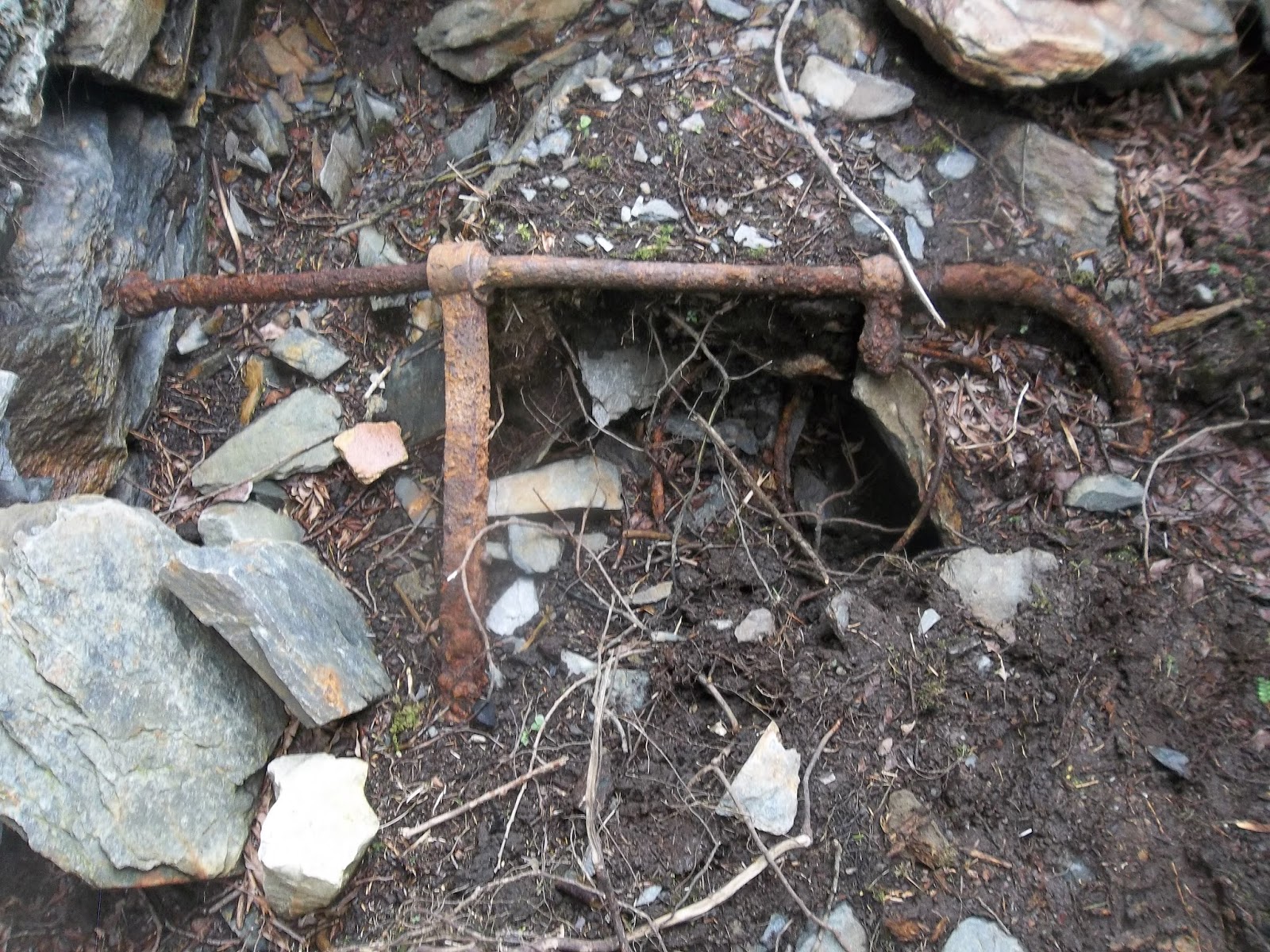
30.09.14 Ffynnon Elan, Dolwyddelan.
Back at Dolwyddelan to continue clearing the well. Bill and the gang have been busy and the whole place is begining to look like the site of an ancient well, the trees have been cut back and once the area surrounding the well is landscaped and has re-grown naturally this is going to look good.
I spend my day clearing around the rear wall of the well structure.
The aim really is to define and make sure that we establish the edge of the rear wall of the well. This involves hacking away through tree roots and then trowelling loose soil.
John at work :
Rear wall of well structure :
A lot of soil is cleared, there is a bit of sweat involved as the sun comes out and bathes Dolwyddelan in that late September sun.
Bill is happy that we have done a good day's work.
Bill has cleared a small cistern just outside the well which is probably placed there to clear the silt from the pure water. The cistern is constructed from cut slate.
Again there is a discussion about which slates were cut by which saw - I need to get a list of dates for when the saws were introduced and the cut marks they produce so that I can explain this better.
Today's finds tray : not sure what the iron ring was for? It seems to have had a bracket hole which may have been to hold it on to a wall or beam?
15.07.14 Ffynnon Elan, Dolwyddelan.
I joined Bill Jones & Co today at Ffynnon Elan. I was here a year or two ago and we had another look for some of the paths / the old road leading towards the well. We have exposed something that could be an old track / or the road - we had found this previously in another trench. It's just a section of darker more compacted soil with stones - it's not a metalled surface, but the compacted soil does show up as much darker than the natural clays - which are orange-ish colour. This leads up towards the well - so we are definitely in the right place.
Meanwhile Bill and John were hard at work clearing the well itself - the side walls are showing up nicely and also a small alcove / shelf at the top of the northern wall - presumably this was for offerings or a statue? This is a south facing well - we did have some discussions as to the significance of a south facing well. Let's do some more research on this and post up our findings !
Meanwhile up in my trench we found a piece of pottery that might be Midlands Purple - not sure yet, I might just tweet it to see if any archaeologists out there have any opinions.
Hen Gastell, Llanwnda, Week 1, (July 7th-11th)
I only managed one day at Hen Gastell during Week 1, due to commitments at Meillionydd and doing some tour guiding work, therefore I am going to copy you in on Jane Kenney's Blog from the Gwynedd Archaeological Trust Facebook page :
“Last Thursday and Friday the mini-digger opened our main
trench at Hen Gastell, under my careful supervision. The turf and mixed
ploughsoil were removed to expose layers with undisturbed archaeology. If we
had to do this by hand it would have taken all three weeks of the dig just to
open the trench. A large canteen and other facilities were delivered so that we
have some comfort on the dig, and the farmer and his wife (Tom and Barbara)
were very helpful in getting everything in place and sorted out.

On Monday the first volunteers arrived and the first job was
paperwork and a health and safety induction but eventually they got on to site
and we could start work. The main trench is in the middle of the monument. This
trench needed a basic clean to get rid of the loose soil left by the digger.
Everyone worked really hard and got the hang of trowelling quickly despite most
never having done any before, so most of the trench had been cleaned by the end
of the day. There were some threats of rain and a slight shower the weather was
generally very good.
Tuesday some new volunteers and some returning from
yesterday. Now we can see things a bit better we can target more detailed
cleaning to define features more clearly. Neil and Dan (GAT staff) took some
hardy volunteers to open a smaller new trench over and behind the outer bank.
This was deturfed by hand, which was hard work. We will get the visiting school
children to start trowelling this trench down for us, but we hope to use it to
investigate the outer bank that surrounds the northern side of the monument.
The sky turned very dark at one point and there was a few spots of rain but
again the weather was very pleasant.


Even though we have only just started archaeology is showing
through. We have dumps of material that formed the low bank around the interior
of the monument and dark splodges across the main trench appear to be cut
features (holes dug by people in the past that have been infilled by different
coloured soil to the natural gravels). I don’t want to speculate just yet what
we might have but I’m hoping for the traces of a building. We will see what
tomorrow brings.
Wed / Thurs.
Work has been going really well at Hen Gastell. The
supervisors really had to keep running around all day as training gets properly
underway. Yesterday we finished cleaning the site and I took a photograph of
the whole site. You can start to see the differences in colour showing through.
The dark patches are possible archaeological features and we started digging
them yesterday and some were half excavated by the end of today. Volunteers
were learning how to take photographs, to draw plans and to fill in context
sheets recording what deposits look like. So much was going on.
And
what have we got? There are definitely at least 5 postholes, which is really
exciting, because postholes mean there was a building (or at least one). We
know these are postholes not just pits dug for other reasons because some have
stones round the edge to pack the post in place and some even have the traces
of the post itself. If a post rots away in its hole that space that was taken
up by the timber will gradually fill with soft soil, which looks and feels very
different to the compacted soil and stone that was packed around the post. This
“cast” of post is known by archaeologists as a “post-pipe” and most of our
postholes so far have them. Some of these post pipes are square showing that
neatly squared off posts were used. We haven’t explored enough features yet to
know what shape any possible building might have been but this suggests that it
is just a matter of time and more hard work and many of our questions will be
answered
Friday.
"We are at the end of our first
week and progress has been very good. The weather has also been kind, with
today being if anything too hot. As well as the archaeology in the work in the
main trench Anita, the GAT Outreach Officer, has been taking children from
local schools round the site and the children have been helping us clean up the
new trench behind the outer bank. They have been doing some trowelling and have
been finding some objects dating from the past couple of centuries. The
children have enjoyed seeing archaeologists at work and doing their bit to
help".
Jane Kenney (site director)”
We've had some good press coverage for Hen Gastell to date see
2/07/14 Hen Caerwys
Similar story at Hen Caerwys this year, not enough time or days in the week to have much time on site so I dive in for a morning before teaching another Adult Education group in Mold. But I have a cunning plan - in the afternoon I will bring my class over to Hen Caerwys to see the excavations !!!
Again it's good to catch up with the team, see some familiar places and I join Will and Bob down at one of the platform houses and spend my 4 hours checking out something that may have been an out building but by the end of the 4 hours cleaning begins to look a lot more natural - possibly a quarry for some of the limestone blocks for one of the platform houses?
I think we agreed this was not a structure, although there were some parallel lines and some limestone blocks that looked more wall than natural. I look forward to the interim report to see what they eventually thought !
View down on one of the platform houses (medieval)
Will giving the group from Ty Pendre a guided tour
Caroline from Cadw introducing the site to the class from Ty Pendre
30/6/14 Monday morning @ Meillionydd.
I teach an Adult Education class for WEA Cymru at Nefyn every Monday afternoon and it works out quite well to have a morning's digging at Meillionydd each Monday morning before zooming off to Nefyn. The frustrating part it that it means the day at Meillionydd is very short, but I hope that my 4 hours or so excavating helps things along just that little bit .....
We clean up the 'metalled surface' going through the earlier (phase 1) inner entrance and underneath the outer bank (later double ring phase) for a photograph and get another chance to clean up around the outer entrance. Still looks good - still a possibility that the outer entranceway was changed at some point.
View up through outer bank / entrance :
View down through outer bank entrance
What has also become clear is an entrance to a roundhouse (mostly excavated last year) which has been cut into the outer bank - suggesting a later phase when the outer bank was not as important / out of use ? What we do have at Meillionydd for sure is the use of the site over a long period of time with a lot of changes and adapting going on. This is complicated in one sense but great for trying to work out the archaeological sequences and relationship between various features - it makes the work challenging and interesting.
23/6/14 Monday morning @ Meillionydd.
A fresh view of our work on Friday (see below) convinces us that there may well be 2 phases to the outer bank that we are working on, that we have yet to define the bank terminal and that we have quite a bit of soil and stones still to shift before we find any metalling (road surface) beneath us (hopefully).
During the cleaning we come across our first piece of Mynydd Rhiw stone this season, it looks a bit like a flake rather than any tool.
In the afternoon I bring a group over to the site from Nefyn (Heneiddio'n Dda) and they are guided around the site by Lowri and a couple of the other student volunteers.
Another challenge is that we have one wheelchair in the group and no way will we get the wheelchair up to the site, so we go for the option - drive onto the field towards the tent / toilets and do a tour from there. Another student is on hand to show finds and give the tour through the car window ! This is a great example of outreach / archaeology for all / inclusiveness - well done Meillionydd students !
Professor Raimund Karl at work :
20/6/14 back at Meillionydd. (Open Day 1)
It's so good to be back, what a gorgeous day and we have a saying in Welsh 'Agosach at y Nefoedd' which translates as Nearer to Heaven. Even as a pagan(ish) non-believer I still maintain that there is some truth in this at Meillionydd, here in Llyn. This is a truly special place. I never forget this or take this for granted - as always it is a privilege to excavate at these special places.
I am "re-introduced" to the site - a lot has happened during my week's absence - we have the faint outline of a roundhouse (inner and outer edge of wall) cutting into the Inner Bank - see below :
We have also exposed the Northern terminal of the Outer Bank - see the line of stones
I am put to work with Pete, a regular volunteer here at Meillionydd and we start to explore the southern side of the Outer Bank - see if we can find the terminal. It's a cleaning job, then trying to take away the collapsed stones and scattered rubble.
It takes the best part of the day to clean and remove the stones that are 'floating' ie stones that lie in soil and are not structural. What is interesting here is we appear to have two lines to our bank. Possibly the outer face which is the upstanding boulders - and possibly an different phase or a foundation which is the stones to the right of the boulders (centre of the picture). The lower level of stones do seem to suggest foundations of a bank rather than just debris from the bank - but let's put a question mark here until we have another fresh look on Monday morning !


To to add to the excitement, Pete had found the metalled surface (small cobbles) that went through the entrance - again there may be at least two phases of metalled surface here. To the right of the bank in the picture below, what we actually have is an earlier phase of cobbles / metalled surface which belongs to the earlier palisaded enclosure - as these cobbles go underneath the bank (from the later double-ringwork phase)
As I am cleaning I realise that I am not picking up the metalled surface and with Pete and Ray on hand to discuss we start to realise that there may be a cut in the bank - see all the rounded stones - possibly a drainage gulley from the roundhouse just beyond. This has then cut through the metalled surface - which would explain things and the gulley runs out through the entranceway.
Ray stands astride the 'cut' the gulley going through the bank possibly ? There are certainly larger boulders either side of this cut.
Wheew, what a relief - I joked that I should not have used that mattock while they were at tea break, but I was pretty certain that I had not missed the metalling so there must have been another explanation. This was a good day of archaeology - lots of stuff to think about and try to make sense of ..... and it's so satisfying at the end of a good day's work to feel that we have made some sense. Hopefully now on Monday we make yet more sense !!!!
9/6/14 Meillionydd (Day 2 for me)
Mynydd Rhiw is covered in mist, it's getting pretty wet and any chance of a nice clean up before a photo is abandoned by 10-30am. We retreat to the tent ......
By 11am it's cleared up again, the breeze soon dried out the site and our wet waterproofs and we get on with the job of cleaning this corner of the trench in-between the inner and outer ditches. The line of stones showing up may well be the first hint of the quarry hollow or possibly the line of our u-shaped ditch which preceded the two banks. We still need to go down a few centimetres to get this defined but it's encouraging that things are beginning to show up
I say Day 2 for me, but it was morning only, as I had to shoot off to Nefyn to take the local WEA class on a field trip to Llanfaelrhys Church - just on the other side of Mynydd Rhiw in the afternoon.
Elsie Eldridge the artist (and wife of R.S Thomas) is buried in the churchyard as are the Keating Sisters of Plas yn Rhiw
My day ends with the Princes of Gwynedd, another field trip, this time for Bangor University Welsh learners who end their course with a visit to Dolbadarn Castle. We talk J.M.W. Turner, William Marshall, Dinorwig, landowning gentry and more in Welsh, slowly and clearly with a few bits of translation thrown in.
Long day .... but a good one ......
6/6/14 Meillionydd (Day One for me)
It's like re-joining the family, here we are again at Meillionydd and it's so good to be back, back on such a wonderful site and back with many familiar faces. OK it's only the end of the first week so the site is still being cleared and cleaned. I have only managed to get down on the Friday because of lecturing commitments so I have missed most of the de-turfing but it's straight into mattocking as last year's excavated roundhouse has to be uncovered - good to do some hard work - keeps you fit.
By late morning we have got down to the black plastic covering last year's work so I am shifted over to the area between the Inner and Outer Banks - basically just south of the inner bank to clean up that layer and see if anything comes up.
By mid afternoon we already have something that looks suspiciously like packing stones in a post hole.
Last year we had an u-shaped ditch in this area - which had been cut by the quarry hollow for the inner bank suggesting that the u-shaped ditch belonged to an earlier phase of enclosure of the hilltop. Our next question I suspect will be to see if we have any more post holes and what they belong or relate to.
We should in theory pick up the eastern end of the u-shaped ditch as we carry on troweling down in this area.
One of the interesting aspects of excavating in between the Inner and Outer Banks is that we might well answer some of the questions raised by Graeme Guilbert see below in '
Understanding the Marches', I quote myself here :
He also made a great point about the lack of excavation work in between the banks and ditches of forts etc - an area where we do not know enough perhaps about the function of these spaces (between the defences as it were).
An Interesting Find.
This object was handed to me after a recent lecture at Pencarnisiog, Mon and was found on a farm between Llanfair PG and Brynsiencyn. The idea was for me to identify the object and provide the owner with more information.
Thanks to Bill Jones of the Dolwyddelan Historical Society for pointing me in the right direction. This is what is known as a nesting or nested graduated cup-weight. The piece above would have originally been part of a set.
A Google search reveals that most examples are on ebay for sale with very little information on the actual objects.
Description
Four examples of nested cup weights are found within the Squibb Apothecary Collection, all of which were manufactured during the (c.) seventeenth century in the Bavarian City of Nuremberg. At this time, as an imperial-free city, Nuremberg maintained a strong economy supported by a sizable middle class. Prospering within this class was a strong contingent of artisans who were considered to be the elite of Europe. Included amongst these craftsmen was a skilled and exacting guild of cooper-masters who held a monopoly over the world's production of nested-cup weights.
- The nested cup weights were designed to make the transport of weights, essential items in most commercial transactions, more convenient. The idea of nesting weights, which dates back to Roman times, was to increase the portability of weight sets by compacting an entire group of weights into a container. In the nested cup form, a series of weights shaped into cups are set one into the other, forming a stack which is stored within a house vessel. Each of the cups fit precisely into the next, larger sized cup, which each larger example weighing exactly twice that of the one previous. Furthermore the weight of the house was made to equal the total weight of the cup stack. In this manner, systems of weights were created that allowed for precise and flexible measurements, and could be contained within organized conveyable units.
- During the 16th century, the appearance of the nested cup weights became increasingly elaborate, as the Nuremberg copper-masters adorned the with houses in styles inspired by the German Renaissance. House lids were embellished by such fantastical ornaments as mermaids, dolphins, sea-horses or soldiers, and geometric designs, or scenes like hunting excursions were often stamped upon the sets in circular patterns around the house body.
- The copper-masters or "rotschmiedmeisters," who made nested weights began to stamp a unique "makers mark" upon their wares. Weight adjustments from various cities, whose jobs were to verify and adjust weights to local standards, also left distinctive marks upon the sets they examined. It is thought the use of these impressions identify both the manufacturer, and the place of use where a given set might be found.
- Interestingly testing with an X-Ray Flrorescence Spectrometer showed the metal content of the outer container and lid to 75% copper, 13% lead and 7% zinc with trace metals of antimony, iron and Niobium. All measurements are approximate.
20th May, Penrhiw Hone Quarry, Mill Building, Moel Siabod.
The battle today is on two fronts, one to clear even more collapsed debris inside the mill building to enable us to get a better look at what we now believe to be the original wheel pit on the site and the second even tougher battle is against the 'piwiaid' (midges). They bite, they irritate and they get up your nose.
We have to work through collapsed wall stones and roofing slates before we get down to 'archaeology' but as we keep discussing on this site - even the collapsed material tells us a story - it's all archaeology and certainly not 'rubbish'.
All complete roofing slates (llechi mwsog) are kept for recording
We have a visitor just after lunch time
Most of the day is spent clearing rubble. We come across another floor level - slab underneath all the collapse. We have at least 3 phases of flooring in the mill and it's pretty certain that they just put down flagstones on top of sand deposits as and when they needed new flooring rather than clear out the sand from the mill building. Another flagstone is uncovered ...... there is much more work to be done and more rubble to clear, therefore I expect we shall be back next Tuesday.
Understanding The Marches : A Day School To Celebrate The Work Of Bill Britnell and CPAT
I started my archaeological career with CPAT back in the early 1980's working at Four Crosses, Caersws, Capel Maelog and Montgomery. This was a day I would not have missed for the world and it was important on two counts, 1, the quality of the papers and speakers and 2, a chance to catch up with old friends and colleagues.
Chris Musson outlined their origins as RAG - the Rescue Archaeolgy Group - a group of highly motivated and idealistic young archaeologists who probably set the bar for the standards of archeological excavation that we know and respect today.
Their basic philosophy was that a few highly skilled archaeologists were far more efficient than a bunch of many more un-experienced archaeologists - there is truth in this.
I suspect they were probably not the group most suitable to run community excavations with people who had never dug before, but then that was not the aim of RAG.
Graeme Guilbert, another of the original gang, also gave a good paper on Iron Age hillside enclosures such as Collfryn and hillforts such as Breidden. Again it was clear that the excavations were of an extremely high standard. Guilbert made an interesting point about re-visiting reports, re-assessing things and being prepared to question even your own work with hindsight (maybe this is obvious) but it was refreshing to hear.
He also made a great point about the lack of excavation work in between the banks and ditches of forts etc - an area where we do not know enough perhaps about the function of these spaces (between the defences as it were).
Guilbert was a great speaker and obviously very focused.
Nancy Edwards's paper on early churches - and the lack of evidence for pre-Norman wooden structures at many church sites seemed to suggest that a lot of these sites have their origin as cemeteries rather than church buildings. This is certainly an argument that needs to be developed and discussed on a wider platform.
Frances Lynch on the closure of burial chambers was brilliant as expected.
The other highlight of the day was Bill's work on the Archaeological Landscape of Llangollen and the fact that the Ladies of Llangollen and author and anarchist John Cowper Powys were included in this survey - we had a very good discussion on what constitutes culture and the cultural landscape. This pushes at the boundaries of archaeology - but it is great stuff. We are in Wales and culture matters.
I was inspired not only by the debate but by the fact that Bill Britnell had already realised this - he had already done this - he is indeed a visionary and pioneer.
A great day, and a huge thanks to Frances, Jenny and CPAT for making all this happen - archaeology should inform and inspire - this day did both.
My final point is that some speakers (this is in general within archaeology and not specific to this session) really do need to face the audience and speak clearly - and NOT have their backs to the audience. This was most obvious at Aberystwyth recently for CBA Wales meeting - quite a few of us struggled to hear the speakers who turned their backs on us to look at their own slides. This is really not good practise - someone should point this out !
15th May, Hone Quarry Mill Building (Chwarel Penrhiw) Moel Siabod - Day 8.
Further excavation work has now revealed and confirmed that we do have a pit, almost certainly a water wheel pit, underneath the structures described below (13th May).
The braces and machine frames unearthed all lie on top of, and are fixed to, the slab that overlies and closes the pit and therefore must have been in use after the closure of the pit.
The pit lines up with the gap in the northern wall for a wooden leat and also the stream heading down off Afon Ystumiau - therefore all this points towards an earlier water wheel (before the addition of a new water wheel pit on the eastern side of the mill)
We have caught glimpses into the pit using torches and we are looking at a depth from floor level around 1.5m, length around 3, and width around 1.5m enough for a 12ft wheel with 36" buckets.
A glimpse into the pit :
Bill and the measuring device :
This earlier water wheel was therefore enclosed by the mill building and to the south -east is the outflow for both water wheels - again lining up nicely with water wheel (1).
Water wheel 2 and pit can be quite clearly seen to have been added against (abutting) the eastern gable end of the mill building.
Most of the day was spent clearing the machinery / braces and structures and uncovering as much as possible of the slabs overlying the pit. What is now clear is that we have a few more days work up here before we are finished.
All the other excavation work around the reciprocating saw area has now been back filled and most of the finds etc stored.
13th May, Hone Quarry (Penrhiw) Moel Siabod - Day 7.
The excavation work up here at Chwarel Penrhiw, Hone Quarry on the southern slope of Moel Siabod is drawing o a close. It's almost sad to see it coming to an end. Getting to grips with some Industrial Archaeology has been great fun and a great experience. The challenges involved in interpreting the workings are best explained using the picture below.
On the eastern end of the mill building we have found this structure and this overlies a pit, possibly a wheel pit underneath.
We have at least 3 parts here :
A frame each side designed to hold something - we can see that from the bolt holes on top
then we have a central plate which is slightly off centre to the bracket or frame which would have held a brass bearing in the slot which in turn held a shaft drive or rod.
It is easier to envisage the shaft drive baring frame and the two frames either side as belonging to the same phase.
But it is also clear as the drive shaft frame is clamped to a huge slab and this slab overlies the pit that the operation or use of the pit must be earlier than this machine because the machine and slabs close the pit.
We have gaps in the slabs and we have been able to photograph and extend measuring rods into the pit.
The ring around all this is another mystery. As we clear away the sand and rubble the ring is uncovered - it appears to be one piece joined by a bolt. As it rests on the sand it may have been placed around these structures or fallen over them later - it does not appear to be joined structurally in any way.
Detail of the side frame :
Detail of the baring slot and frame for drive shaft :
Note : The pit is visible as are the clamps on to the covering slab. A brass baring from a similar device was found in another part of the excavation.
Detail of the central plate - relationship to other pieces unknown :
View into the pit below :
We are back up tomorrow (15th May) to try and finish things off and make a bit more sense of all this. I'll take my notebook !
8 April, Hone Quarry, Moel Siabod - Day 6.
Anyone joining the Blog needs to scroll down and start at the beginning. We are excavating at the Hone Quarry on Moel Siabod near Dolwyddelan with the Dolwyddelan Historical Society under the directorship of Bill Jones. This is my sixth day up here - and if you read the Blog you'll see that the challenges are to try and make sense of the reciprocating saw and it's workings.
This morning was spent examining one of the four adjusting devices at each corner of the frame holding the reciprocating saw.
The 4 bolts would have secured the adjustor to the wooden beam at each corner. Most of the wood surrounding this particular adjustor was pretty well rotten - very little remained.
here's the adjustor removed (see pic below)
It's almost impossible to make out but just visible is the timber at the base of the frame and then going under the metal frame of the saw is what is left of a beam extending along the frame. In the middle would have been the corner post for the overhead frame - the stones just about indicate the edge of the rotten timbers.
On the other corner of the saw, things are slightly clearer - again the adjusting device has been removed. The slate and dark patch of earth indicate the position of a timber post.
As the timbers have perished, we are actually finding that these adjustors are pretty well sitting on the sand - so in effect, often no, or very little, structure remains - as we clear the sand the adjustors basically 'float' and have to be removed. All the adjustors are the same - all with 4 bolts to secure them to the timber and all with central adjusting bolt.
The big question of course is what did they adjust - it had something to do with the position of the overhead frame holding the saw - might it have been a fine adjustment for the angle of the saw ?
Again as we say - good question. What we really need is to see one of these things in working order !
A couple of finds - not sure what these are but they are obviously part of the whole mechanism
The other find of the day was 2 levels of flooring running alongside the saw and up to the wall of the mill. The edge has been marked out by slate slabs and at one point a metal peg secures the edge slabs in place. The slate floor or 'crawia' was cleaned and examined and we realised that another floor of slabs can be seen extending underneath the top level.
4 April, Hone Quarry, Moel Siabod - Day 5.
We have established that there are two 'arms' coming out from the frame of the reciprocating saw, one is broken and the other shown below is pretty complete. The two arms would have then joined the rod from the water wheel mechanisms - again the join can be seen in picture below. What is really interesting is the preserved beam underneath this connecting arm and next to it, revealed by careful trowelling is the 'shadow' of another piece of beam- completely rotted away.
Both pieces of wood end at the point where the two arms join the rod.
Therefore my theory below about the beams being used to hold the saw frame in place is no longer valid - makes no sense.
Also the alignment of the beams is not quite the same as the arms. The beams have no 'mechanical' function with the saw itself - therefore it's something from an earlier phase of the saw or something to protect the arms from the floor ? Again - makes no real sense,
we need to see a working reciprocating saw !!!!
The stain of the rotten beam is visible to the left hand side of the preserved beam.
With arm propped in position it's clearer how the whole thing is laid out. We are now pretty certain that the beams do not extend to the wall of the building and end just below the 'join'.
Our challenge now is to work out the function of these beams.
To the left hand side of the saw I could not make out any further beams - certainly nothing convincing. There's a small dark patch on the left of this picture but I think this is animal burrow as it's a pretty neat round hole.
There are markings obviously from scratching on the slate slab just outside the frame of the saw - again no idea as yet how these were caused and whether the stone is in it's original position of course ??
Questions, questions ....
The happy team (below) - Bill's got his left hand on the railway track coming into the cutting shed
Weather permitting it looks like were back up there on Tuesday.
1 April, Hone Quarry, Moel Siabod - Day 4.
Still exploring the reciprocating saw, I must admit 'Industrial Archaeology' is catching. The challenges of excavating something that actually worked and functioned and trying to work out what the various bits and bobs did is quite brilliant. There is a lot of discussion on site ......
Now then, we are working in the mill or cutting shed and it's quite obvious that the roof had collapsed at some point after the building went out of use. Roof slates cover everything and Bill identifies some of the 'older' slates as llechi mwsog - this means roofing slate that had a wooden peg and were insulated by moss.
The Welsh name for the person that stuffed the moss between and under the slates for insulation was 'mwsogwr' - translates roughly as Moss-man.
The llechi mwsog are also identified by having off centre holes for the wooden pegs.
This gives you an idea of the debris / collapsed roof (see pic below)
There are also examples of roofing slates with central peg holes
The reciprocating saw would have been raised over the cutting floor by use of a winch, and the wheel used to raise the saw was found on site
Returning to my corner of the site, more wood was uncovered. Time will tell but this seems to be a piece of wood possibly used to hold the frame in place as it is at right angles to the main saw frame - possibly even as a wedge against the wall of the shed ?
The slate on the right of the picture appears to have been placed on top of the sand to keep the adjusting screws of the saw away from the sand. The slate has fractured and there is a piece of metal and a piece of hone stone wedged under the saw to raise it from the slate. It's all a bit DIY or just doing whatever is needed and practical to solve a problem.
As we clear, all these little things are revealed and the story unfolds and develops. Care has to be taken as much of the wood is in bad condition but the piece above was in pretty good shape. The next problem is that it disappears under the baulk - so the usual archaeological story - we might have to extend our trench a bit.
More work to be done here - I think we may be back on Friday ......
25 March, Hone Quarry, Moel Siabod - Day 3.
OK, so the job today is to continue exploring this base or cutting floor that came to light yesterday. By lunchtime I have it cleared and there are indeed a few small pieces of the base stone surviving - the rest having been destroyed by a combination of sawing and the process of placing the hone blocks for cutting on the base stone and the associated erosion.
Pic : lower cutting floor - upper cutting floor visible to right
pic : close up of remains of base stone / cutting floor - with saw marks visible.
pic : view down on reciprocating sand saw - on right 10 saw blades, in middle lower cutting floor, the stone slabs surround parts of the frame. The tree LHS is growing within the saw - which is bad news for the archaeology !
Once we had documented this lower floor we then started the process of removing it and found a layer of metal / iron mixed with sand which was basically solidified - the trowel was NOT going through and we had to resort to hammer and chisel to cut off blocks at a time to reveal a series of timbers underneath this lower cutting floor.
The timbers presumably are the floor below / base of the reciprocating saw structure.
pic : wooden beams exposed
There is a cross beam running alongside the saw with some mechanism associated - just below the arms to move the saw - not sure yet what is going on here ? I keep saying to Bill, I'd love to see a working saw in order to compare what we have here at Moel Siabod.
There is also a fireplace in the cutting shed - maybe in the area where they were giving the hone stones the final polish - it might well have been cold work in winter with water being involved in the cutting process.
Another interesting feature - just chucked in to the water wheel slot, is part of a bed, suggesting that the western building might well have doubled up as a barrack as well as a smithy ? But they obviously did go to the trouble of bringing a 'comfy bed' up here on the southern slopes of Siabod.
Bill suggests that between 4 and 7 people were involved here between the quarry and the factory.
pic : bed frame - discarded.
24 March, Hone Quarry, Moel Siabod - Day 2.
We're back up on Moel Siabod and working in the middle of the reciprocating saw. Clearing the sand I eventually hit a hard surface which turns out to be another 'sacrificial' surface - or cutting base / floor - about 6 inches down from the upper base.
The side of the upper saw structure is clear and quite hard and full of iron so peeling away the sand fill is easy. There is no doubt that what I have found is an earlier cutting base and on cleaning, it becomes evident that there are very degraded wooden beams underneath this.
Right at the edge we are able to lift a piece of the base stone to reveal the wood underneath and confirming that what we have is a very damaged / degraded / battered stone that once provided the base for the hone stones to be cut.
Pic : piece of the base stone for cutting - Bill Jones refers to this as the 'sacrificial stone' - the saw would have cut into it and eventually the stone base would have been replaced. The groove lines on this piece are the lines of the saw cuts.
Pic : very degraded wood / timber below the cutting base / floor.
We are therefore looking at different phases of usage - or perhaps the base of an earlier saw ? Tomorrow hopefully we should be able to look at the relationship between the upper floor and this newly found lower floor. Obvious thing to look out for is whether the earlier floor continues under the upper floor to the side. So far we have been clearing the middle of the saw - so the relationship is not yet entirely clear - time will tell.
This was a great example of 'following the archaeology' - none of us had expected this lower floor - it was found by careful trowelling and letting the archaeology guide us ......
Interesting find was this 'nog' see below - this would have fitted into a slot. We also found some hand-made nails.
17 March 2014. Hone Quarry, Moel Siabod.
First day of actual digging of 2014. Great to be back on a site, trowel in hand - I'm thinking it'll soon be Meillionydd again.
I've been invited by Bill Jones to help out for a couple of days at the Hone Quarry, on the southern slopes of Moel Siabod SH 722541.
This is a good / long drive up a forestry track from Dolwyddelan, it feels like an adventure, and it is good to be doing some Industrial Archaeology.
Bill gives me a quick tour of the site and then we get to work cleaning around the
reciprocating sandsaw - they have not been up here since November - so it needs a good clean and then a look/see what our plan is for the next couple of days.
The Welsh word for this kind of saw would be
hwrdd.
Above : This is the building containing the saw - there is an additional building on the western end and the site of the water wheel on the eastern end. A railtrack from the quarry some 500 yards to the west runs through the door of the building.
Above : This is the western extension - added on to central building later - has flagstone floor and hearth / furnace.
Above : Railway track coming into central building.
Above : Location of water wheel - only pit remaining - eastern end of buildings.
The reciprocating sandsaw was powered by the water wheel - we can see two rods connecting the wheel mechanisms and crank to the saw frame and it appears that there are 10 guiding rods and 10 blades each side of the saw. The saw used sand and water as lubricant / abrasion and the building floor is covered in sand dust / debris.
Above : one rod remaining RHS and link for other rod on left (middle of pic)
The base 'sacrificial' stone which provided the surface for the hone to be cut is in poor condition but the cut marks are clear on the surface where the saw cut through the hone stone. I think the stone surface is pretty well demolished / disintegrated near the centre of the saw with only a few pieces of any thickness surviving at the southern end.
Above : section through base stone - saw marks visible near 10 guiding rods but much degraded at centre of saw.
The guiding rods were almost like large nails - probably hammered into the sand or wooden frame and acted as guides for the saw blades - the pointy ends are still clearly visible.
Most of the day was spent discussing what we have on site and trying to make sense of the construction of the saw. The fact that the cutting base lies on top of sand deposits would suggest that this belongs to a later phase of the saw and was put down after some inches of sand deposit had collected under the saw.
We also found sections of the wooden frame / floor / base underneath the saw. The bad news is that there is a tree growing on the eastern section of the saw.
Piece of saw blade in situ from eastern half of saw.
Piece of saw - worn in middle.
Interestingly the Romans used a similar principle at Hierapolis with a water powered sawmill
http://en.wikipedia.org/wiki/Hierapolis_sawmill


